
Google adds NYC mass transit to Maps for mobile
Sponsored link
Take Google Maps for mobile in your pocket, so you can go wherever you want and make sure you won’t get lost. Yeah, it’s the main objective of this latest Google’s application. Google Maps for mobile with public transit directions is available (at http://m.google.com/nyc) for Blackberry, Windows Mobile, Symbian Series 60, and many Java-based phones.
So, don’t miss it!
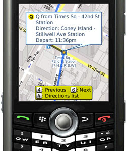
Now that Google Maps can give you subway, train, bus, and ferry directions in New York City, it’s a handy tool for planning a night on the town. But what if your plans change while you’re at dinner?
Luckily, Google Maps for mobile can give you the same public transit directions right on your cell phone! You can plan trips throughout the New York metro area, including turn-by-turn walking directions. With the My Location feature, most cell phones can automatically set the starting point for your trip, even without GPS. And satellite view and Street View (on selected devices) can show you a preview of where you’re going.
So, don’t miss it!
Labels: Google
Translate to:
0 Comments:
Previous Posts
- 3ple-Media helps operators to monetize mobile mult...
- ChangingWorlds launches Orange World portal in Aus...
- GyPSii helps mobile users to reserve hotel in China
- Sony Ericsson showcases X1
- Beautiful G705 and G705u pictures
- More IDP-100 pictures
- Nokia 6210 Navigator Reviews
- LG KS360 Reviews
- 3 Skypephone S2 Reviews
- Sony Ericsson Announces PlayNow Unlimited Music Do...
Post a Comment